Elevation 4

https://www.cloudeo.group/web/image/product.template/82/image_1920?unique=815a972
  • Service Provider​
  • Thematic Information
  • Service Option​s
  • Access Mode​
  • Pricing Options
  • Pricing​
  • Free Trial
  • Delivery Time​
  • Compatible products
  • Mission
  • Sensor & Data Products
  • Data Format​
  • Spatial Resolution​
  • Spatial Coverage
  • Temporal Coverage
  • Accuracy

From 2500€

From 2500€

This combination does not exist.


Provided by Airbus Defence & Space


cloudeo Terms and Conditions

 High precision digital elevation model at 4m spatial resolution.

Interested in Elevation 4 imagery and products?

Fill out a form with all your requirements and we will contact you as soon as possible with a quote!

Elevation 4

Elevation 4 from Airbus provides very high-resolution terrain relief models on demand. Elevation 4 is ideally suited for any relief (urban or environmental). The models are made from Pleiades satellite imagery, with its outstanding agility as a constellation, making it the ideal solution for accurate 3D modeling.

Stereo or Tristereo can be acquired over large areas and processed into a smart 3D database to match any of your needs, including exploration, civil engineering projects, and land management. When you order Elevation 4, production is tailored to your area of interest.

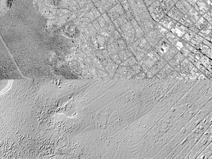
The models come in two formats: Digital Surface Model (DSM; a model of the ground that includes both ground and above ground features as buildings, vegetation, etc.) or Digital Terrain Model (DTM; representing the bare Earth elevation, vegetation and man-made objects removed). In addition to the elevation information, you also receive the original Pleiades imagery used to create it.

Need a sample to test the product before ordering?

Protected by reCAPTCHA, opting in Newsletter, Privacy Policy applied. 

Your sample request has been sent

Our team will message you back as soon as possible in the provided email.

Key features

Up to 3m vertical accuracy at 4m grid spacing

Ideally suited for any kind of relief (urban or environmental)

Tailored to your area of interest

Weather and daylight independent site access to any point on Earth

Based on matching of very high resolution optical stereo imagery

Suitable to HRE40 (E4) standards (military standards (NGA))

Key applications

Transportation

Surface analysis for road construction

3D flight simulation

Intelligent transportation systems (ITS)

Infrastructure

Site selection process

Rectification of aerial photography or satellite imagery

 Line-of-sight analysis

Environment

Modeling water flow

Predicting potential landslides

Extracting terrain parameters

FAQs

Pléiades Stereo or Tristereo automatic matching for DEM production at 4m grid spacing. Processing includes manual editions.

Elevation 4 DEM is delivered with the original Stereo or Tristereo data source.

  • A minimum area size of 100km² is required.

  • A minimum area width of 10km is required.

The EULA of Elevation 4 is under the authority of Airbus Defence & Space, and falls under the Pleiades EULA and the SPOT for ELEVATION EULA.

Request quote

Protected by reCAPTCHA,  I have read and accept the Privacy Policy

People also viewed

Do you have more questions about the product?

We are here for you! Please contact us and we will come back to you shortly!

Specifications for Elevation 4

General Info
Service Provider​ Airbus Defence and Space
Thematic Information Surface elevation; Terrain elevation; Contour lines
Service Option​s DTM; DSM; Bundle
Access Mode​ File transfer
Pricing Options Pre-paid
Pricing​ Per km²; min. order 100 km²/AOI
Free Trial On demand
Delivery Time​ Up to 5 business days
Compatible products Standalone; SaaS
Geodata Specs
Mission Pleiades
Sensor & Data Products DTM; DSM; Pleiades imagery; Orthomosaic; Contour Lines
Data Format​ ASCII; GeoTIFF
Spatial Resolution​ 4m
Spatial Coverage Global
Temporal Coverage On demand
Accuracy 3m vertical/3m horizontal