RegioGraph TeamConnect
RegioGraph TeamConnect, the award-winning geomarketing software, gives you access to powerful tools for optimizing your sales territories, evaluating locations and analyzing markets directly on digital maps. A user-friendly interface allows you to import your company data at the click of a button and use non-standardized criteria and a broad spectrum of powerful analytic tools.
Either you are a b2b or b2c company, start sharing your geomarketing analyses, territory planning, and location assessments online with your team, and start saving time in your daily workflows! Remote work, multiple locations, interdisciplinary teams — today, more than ever before, we need tools to keep things running smoothly and enable digital collaboration.
Data Analysis
All stored data can be found in the overall table.
By searching, filtering, and sorting you can easily evaluate your data.
Your results can be downloaded as Excel or CSV.
Data visualization
The wide range of display options from RegioGraph increases the informative value of the split analyses:
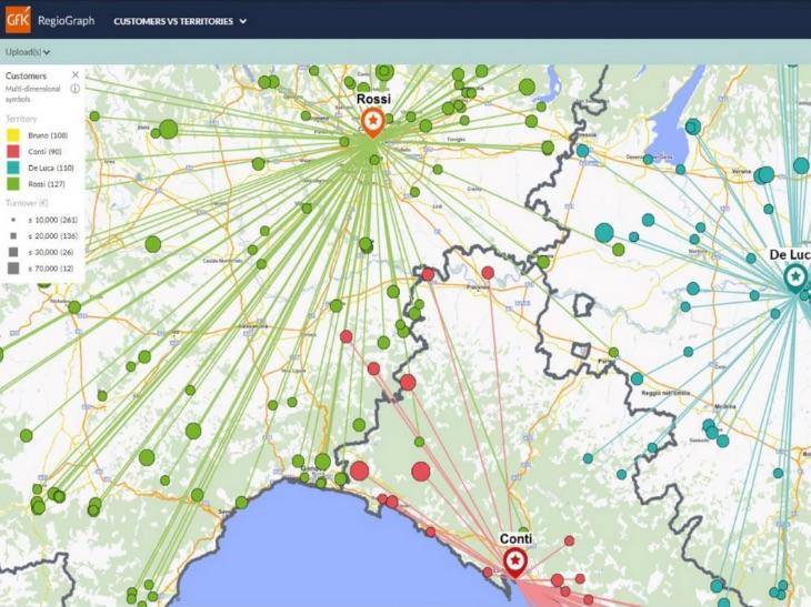
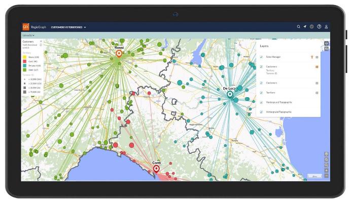
Customer points can be mapped according to sales volume.
The star display and coloring show which customers are assigned to which sales representative.
You can identify whether a customer is located outside the territory.
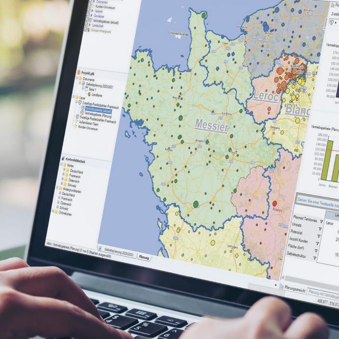
Sales territory changes
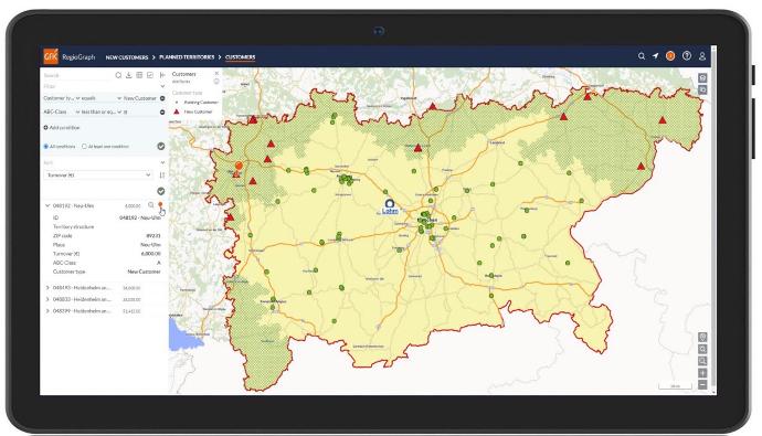
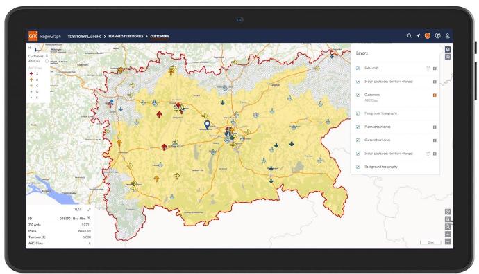
View individual sales territories and look at customer distribution and ABC classification.
The map display allows you to see at a glance which customers are affected by the sales territory change.
For a closer look at the key figures of a new customer, you can "pin" it at the bottom.
Team communication
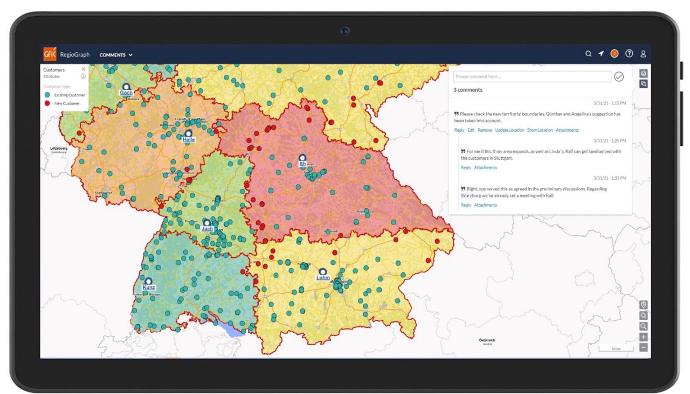
Updates and changes are displayed as notifications.
If you want to exchange information with your colleagues, you can use comments.
Refer to a map section to clarify your comment.
With RegioGraph TeamConnect you are offered access to the established RegioGraph desktop software of your choice:
RegioGraph Analysis, for analyzing your customers, turnover and potential.
RegioGraph Planning, for sales territory planning and optimization as well as street-level customer analysis
RegioGraph Strategy, for detailed location evaluations based on potential and competitor influences
All three packages come together with RegioGraph TeamConnect, the add-on that allows you to share results online with your team for current insights into your planning.
Some key specifications of the RegioGraph TeamConnect add-on:
easy uploading project results to your company’s own web server
browser-based access to shared projects from various end devices
assign access rights for selected viewers
presentation of the diverse market analyses and sales structures on the interactive map
overview of all data in an overall table with search, filter, and sort functions
notifications with location reference for team communication
included in all packages (Analysis, Planning, Strategy)
The latest RegioGraph TeamConnect software version comes pre-installed in cloudeo‘s readily available Virtual Machine environments with a flexible pricing and VM performance according to your exact needs, an easy-to-order process and the ability to instantly-use without further configurations.
Based on the number of viewers that you desire for your RegioGraph sales tools, you can select one of the pre-configured virtual servers that we have prepared for you:
Viewers | vCPUs | RAM | Storage |
<10 | 4 | 16 GB | 200 GB |
10-25 | 4 | 16 GB | 200 GB |
25-50 | 8 | 32 GB | 200 GB |
50-100 | 16 | 64 GB | 256 GB |
100-250 | 32 | 128 GB | 512 GB |
Please note that the VMs have pre-installed the Windows Server 2019 Operating System, with a network bandwidth of up to 5Gbit/s.
Key features
Speed up your sales workflows by sharing up-to-date numbers at any time.
Your data is securely stored on the dedicated server of your choice.
Flexible pricing depending on your team needs.
Simplify the exchange of information by communicating directly online.
RegioGraph TeamConnect comes pre-installed on cloud resources of cloudeo.
Automatically updated virtual machine whenever a new software version is available.
Key applications
Salesforce
View key figures of a new customer (ZIP code, turnover, ABC Class)
Customer distribution and ABC classification
See at a glance the affected customers by a sales territory change
View key figures of a new customer (ZIP code, turnover, ABC Class)
Customer distribution and ABC classification
See at a glance the affected customers by a sales territory change

Team communication
Easily evaluate your data through searching, filtering, and sorting tools
Make comments with references on the map visible to your team
Updates and changes are displayed as notifications
Easily evaluate your data through searching, filtering, and sorting tools
Make comments with references on the map visible to your team
Updates and changes are displayed as notifications
FAQs
RegioGraph Analysis is ideal for visualizing and analyzing your markets, customers, and locations at the level of districts, municipalities, or postcodes.
RegioGraph Planning includes all the features of RegioGraph Analysis in addition to address-based location analysis and tools for creating catchment areas and optimizing sales territories.
RegioGraph Strategy includes all features of RegioGraph Planning as well as comprehensive location evaluation features. RegioGraph Strategy also includes special selection and evaluation tools for working with additionally available micro-data at the level of streets or street segments.
You can incorporate any of GfK's global map sets into RegioGraph. This allows you to carry out international analyses with the software. Geocoding functionality is available for most European countries and selected non-European countries. Geocoding refers to the ability to import company data into maps at the level of street segments. The purchase of a map set for a European country includes GfK Purchasing Power for no additional charge for the country in question. Feel free to contact us for more information.
The software offers a wide range of options for analyzing and displaying your data. So-called "thematic maps" allow you to illuminate values and relationships in your data using colors, sizes, and symbols. For example, you can assign colors to your sales territories according to turnover values; or display your customers according to the assigned representative and generated turnover.
RegioGraph offers numerous powerful tools for optimizing or restructuring your sales territories based on the criteria you specify. The core task involves merging granular geographic levels (such as postcodes) into sales or service territories. These territories are constructed on the basis of the indicated priorities, such as optimal accessibility or an equal distribution of potential. Access to algorithms for optimizing your sales territories is available with the Planning TeamConnect package.
Easily export any maps or tables you create in RegioGraph directly into MS Excel and/or as high-resolution images. You can also create reports and export them as PDFs. The software offers numerous batch functions for creating and exporting map series. Use the RegioGraph TeamConnect add-on to share your RegioGraph project online with colleagues. Your team can access these insights from diverse devices while traveling, with the ability to carry out one-click analyses and table filtering.
Yes. You can use maps in MapInfo format (*.mif) and ESRI format (*.shp). Please note that maps in *.shp format must be saved in the WGS 84 standard (projection: EPSG 4326) in order to import them into the software.
The Virtual Machine provided by cloudeo offers you access to a powerful virtual desktop that is specifically configured for the hosting of the RegioGraph TeamConnect package that you select. The VM can save you time and the costs for new hardware, software installation and licensing, and data acquisition. Al you have to do is select the best VM for your needs from the table in the product description, and you can leave the rest to us.
As for the access, this can happen from any device easily through a Remote Desktop application using the credentials that we will provide you. The latest version of the RegioGraph software that you select will be pre-installed, and you will be able immediately to start performing your sales workflows with the same look and feel as in your current desktop environment.
The EULA of RegioGraph TeamConnect is under the authority of Gfk GeoMarketing and can be found here.