Basemaps derived from satellite data provide a solid foundation for mapping and spatial analysis, empowering various industries with invaluable insights. These visual representations of the Earth's surface offer a comprehensive view, capturing both natural and human-made features. Basemaps also enable detailed examination of landforms, vegetation health, water bodies, infrastructure, and more. Let's delve into the benefits and applications of these dynamic basemaps that shape modern decision-making processes.
Creating Comprehensive Basemaps
Satellite basemaps are meticulously generated using imagery collected by Earth-orbiting satellites. These satellite sensors capture highly detailed images of the planet's surface, which are then processed and seamlessly stitched together. By leveraging different spectral bands such as visible, near-infrared, and infrared, basemaps provide additional insights into land cover, vegetation health, and other crucial characteristics. The result is a comprehensive, up-to-date representation of our dynamic Earth.
The process of creating basemaps from satellite data involves several crucial steps. It begins with Earth-orbiting satellites capturing high-resolution imagery of the Earth's surface. These satellites are equipped with advanced sensors capable of capturing data in different spectral bands, such as visible, near-infrared, and infrared.
The captured imagery undergoes meticulous processing to correct for distortions caused by the satellite's motion, Earth's rotation, and atmospheric effects. Once the images are corrected, they are carefully stitched together to form a seamless and cohesive representation of the entire area of interest. This stitching process involves aligning the images based on precise location and orientation information provided by the satellites.
To enhance the basemaps' accuracy and visual quality, various techniques are employed. These may include applying radiometric corrections to normalize the data, removing cloud cover or other atmospheric interferences, and conducting image enhancement to improve clarity and contrast.
In addition to the visual representation, basemaps derived from satellite data can be enriched with additional information. For example, elevation data can be integrated to create a three-dimensional representation of the Earth's surface, enabling a more detailed understanding of terrain and topography. Other datasets, such as land cover classifications or population density, can be overlaid to provide valuable contextual information for spatial analysis.
Furthermore, basemaps can be updated over time to reflect changes in the Earth's surface. New satellite imagery can be collected periodically to capture the latest information and ensure that the basemaps remain accurate and up to date. This updating process allows for monitoring and analyzing changes such as urban expansion, vegetation growth, and natural or human-induced alterations to the landscape.
The creation of basemaps from satellite data requires sophisticated technology, image processing algorithms, and expertise in geospatial analysis. It is a complex and continuous process that aims to provide a reliable and detailed representation of the Earth's surface, forming the foundation for various mapping and spatial analysis applications.


Foundational Information for Diverse Industries
Basemaps derived from satellite data provide foundational information that supports a wide range of industries in their mapping, analysis, and decision-making processes. Let's explore how these basemaps contribute to various sectors:
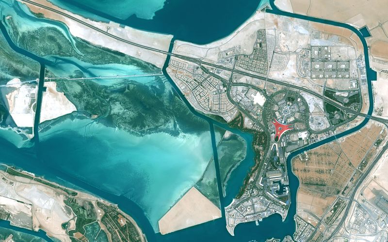
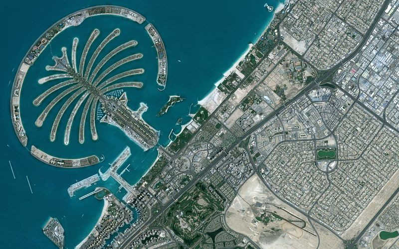
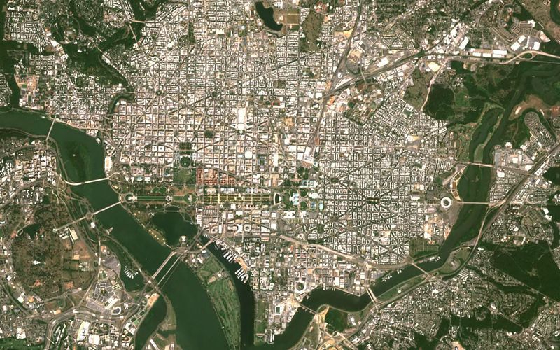
Urban Planning and Development: Basemaps play a crucial role in urban planning by offering valuable insights into existing infrastructure, land use patterns, and population distribution. Urban planners can leverage basemaps to assess transportation networks, identify suitable locations for new developments, and analyze the impact of proposed projects on the surrounding environment. Basemaps aid in making informed decisions about zoning, infrastructure improvements, and urban expansion, promoting sustainable and well-designed cities.
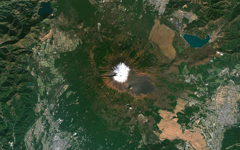
Environmental Monitoring and Management: The comprehensive view provided by basemaps enables effective environmental monitoring and management. These maps facilitate the identification and tracking of changes in land cover, deforestation, urban sprawl, and ecosystem health. By overlaying additional data on basemaps, such as vegetation indices or pollution levels, environmental scientists can assess the impact of human activities on natural resources, wildlife habitats, and climate patterns. Basemaps support informed decision-making in conservation efforts, land use planning, and sustainable resource management.
Disaster Response and Emergency Management: Basemaps are invaluable tools during disaster response and emergency management. By visualizing affected areas, infrastructure, and transportation networks, basemaps aid in assessing the extent of damage, identifying evacuation routes, and coordinating relief efforts. These maps also assist in determining areas prone to natural hazards, such as flood zones or earthquake-prone regions, allowing for proactive mitigation measures and better preparedness.
Aviation and Flight Planning: Basemaps derived from satellite data are of utmost importance in aviation and flight planning. Pilots and flight planners rely on these maps to assess the terrain, identify obstacles, and plan safe and efficient flight routes. Basemaps provide detailed information about the Earth's surface, including topography, landmarks, airports, and airspace boundaries. By visualizing the terrain and potential obstacles, pilots can make informed decisions about altitude, route selection, and fuel requirements. Basemaps also aid in determining alternate airports and assessing airspace restrictions, ensuring adherence to aviation regulations, and enhancing flight safety. In real-time aircraft navigation, basemaps integrated with avionics systems and electronic flight displays enable pilots to maintain situational awareness, verify their position, and accurately follow planned routes, ultimately contributing to efficient and secure air travel.
Check satellite basemap products in cloudeo marketplace
Find the ideal satellite basemap product that will enhance your mapping, analysis, and decision-making processes!
Geographic Data Visualization and Decision-Making
With satellite basemaps as a foundation, data visualization techniques transform complex geospatial data into intuitive and visually compelling representations. In this way, communicating spatial patterns is made easy: data visualization techniques enable decision-makers to communicate to their colleagues, partners, and customers spatial patterns and trends present in basemaps. Through maps, charts, graphs, and interactive visualizations, complex data can be simplified and presented in a visually appealing manner.
One way to perform this is through techniques that provide the ability to visualize and analyze multiple variables simultaneously. By layering different datasets on a basemap, decision-makers can explore relationships, correlations, and dependencies between various factors. For instance, overlaying demographic data, land use, and infrastructure information on a basemap can reveal spatial relationships that inform decisions related to resource allocation and urban planning.
Interactive visualization tools enable decision-makers to interact with the basemap and explore spatial data from different perspectives. By zooming in, panning, and toggling layers, decision-makers can gain deeper insights into specific regions, uncover hidden patterns, and identify areas of interest. This enhances spatial exploration and supports data-driven decision-making.
Data visualization techniques also facilitate temporal analysis by incorporating time as an additional dimension. By animating changes over time of different basemaps, decision-makers can understand dynamic processes, track trends, and make predictions. For example, visualizing the expansion of urban areas over a period of years can inform future development strategies and infrastructure planning.
Need a custom solution for your project?
Tell us about it. Fill out the form below with all the necessary information. Our sales team will gather the most suitable satellite image global basemaps of up to 70cm spatial resolution and contact you as soon as possible.