Population mapping plays a crucial role in understanding and addressing global population challenges. Earth observation, particularly through satellite imagery, has revolutionized population mapping by providing a comprehensive and up-to-date view of the Earth's surface. This technology enables the monitoring and analysis of population trends, distribution, and density at various scales, from local communities to global regions. By leveraging satellite imagery and other Earth observation data, population mapping contributes to evidence-based decision-making, policy formulation, and sustainable development planning.
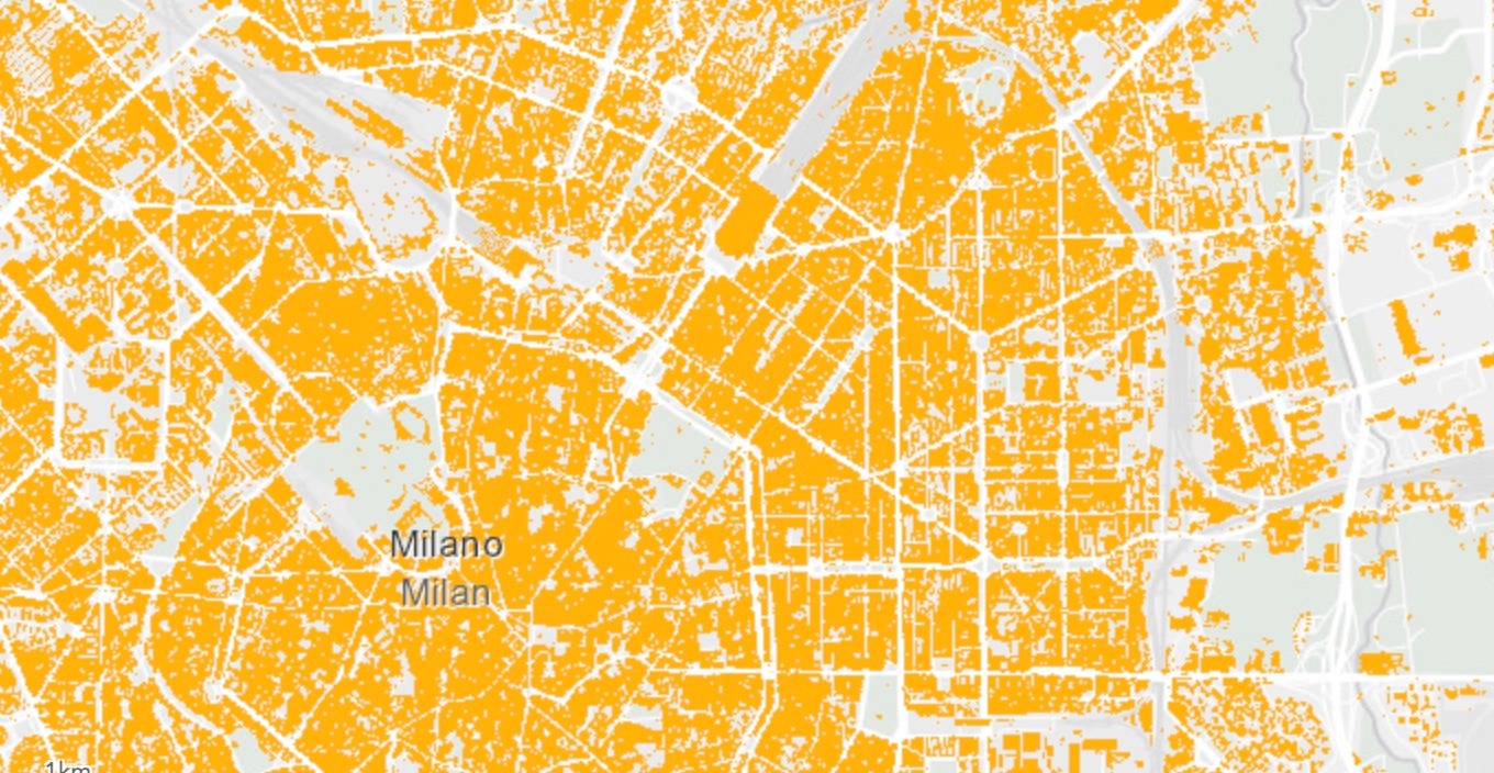
Mapping Population Density in Cities
Urbanization is a global phenomenon that has led to the rapid growth of cities and increased population density. As cities expand, it becomes crucial to understand the distribution and density of populations within urban areas to effectively plan for infrastructure, public services, and resource allocation. Remote sensing plays a vital role in mapping population density in cities by providing valuable spatial data and insights.
By utilizing satellite imagery, aerial and drone photography, and other remote sensing technologies, researchers and urban planners can accurately map and analyze population density in cities. These techniques allow for the identification of densely populated areas, urban growth patterns, and the spatial distribution of communities within the city. Remote sensing provides a comprehensive view of the urban landscape, capturing both visible and non-visible information, such as land use, building density, and transportation networks. This data helps decision-makers gain insights into population patterns and make informed decisions regarding urban infrastructure development and resource management.
Mapping population density in cities through remote sensing also enables the assessment of social and environmental implications. It provides valuable information on urban sprawl, overcrowding, and areas of high vulnerability. By understanding population density, urban planners can identify areas in need of improved services and infrastructure, such as healthcare facilities, schools, and transportation systems. Additionally, remote sensing can help assess the impact of population density on the environment, such as land degradation, air pollution, and resource consumption. This knowledge is essential for implementing sustainable urban development strategies that promote livability, resilience, and equitable distribution of resources within cities.
Identifying Dispersed Communities through Remote Sensing
Mapping rural populations is a complex task due to the dispersed nature of communities and the vast geographic areas they inhabit. However, remote sensing techniques offer valuable tools for identifying and understanding these dispersed populations. By utilizing satellite imagery, aerial surveys, and other remote sensing data, researchers and policymakers can gain insights into the distribution, size, and characteristics of rural communities.
Remote sensing allows for the identification of remote and isolated areas where traditional census methods may be challenging to implement. It helps uncover hidden demographics by providing a comprehensive view of the rural landscape. Satellite imagery, for instance, can reveal settlements, roads, agricultural areas, and other features that indicate human presence. By analyzing such data, it becomes possible to identify and map dispersed communities that may not be easily visible through traditional surveys.
Understanding the distribution of rural populations through remote sensing is crucial for effective resource allocation and service provision. It helps policymakers and development organizations identify areas with limited access to essential services such as healthcare, education, and infrastructure. By mapping population distribution, decision-makers can also devise targeted interventions and allocate resources where they are most needed. Remote sensing also aids in assessing the impact of environmental factors on rural communities, such as vulnerability to natural disasters or access to water resources, enabling informed decision-making and sustainable development planning for these regions.
Δείτε δορυφορικά προϊόντα πολύ υψηλής ανάλυσης στο cloudeo marketplace
Βρείτε τα ιδανικά δορυφορικά προϊόντα που θα βελτιώσουν τις διαδικασίες χαρτογράφησης, ανάλυσης και λήψης αποφάσεών σας!
Satellite Data and Population Insights
Satellite imagery can be used for population mapping due to its ability to provide valuable spatial data at various scales and products. Multispectral imagery, as well as video and night-time acquisitions, can assist in such projects. Here are some key ways in which satellite products are used for population mapping:
Identification of Settlements and Built-up Areas: Satellite imagery allows for the detection and delineation of settlements and built-up areas, providing insights into population distribution. By analyzing satellite images, experts can detect residential areas, urban centers, and rural communities, enabling accurate mapping of population clusters.
Estimation of Population Density: Satellite imagery aids in estimating population density by capturing details such as building density and infrastructure networks. By analyzing the spatial patterns and density of structures within a given area, researchers can make informed assessments of population density, identifying regions with higher or lower concentrations of people.
Monitoring Population Changes: Satellite imagery enables the monitoring of population changes over time. By comparing images captured at different time intervals, researchers can observe urban expansion, population growth, and migration patterns. This information is vital for understanding demographic trends, urbanization processes, and the associated implications for infrastructure planning and resource management.
Mapping Vulnerable Populations: Satellite imagery assists in identifying and mapping vulnerable populations. By analyzing images, experts can identify informal settlements, refugee camps, or areas with inadequate access to essential services. This information helps policymakers and humanitarian organizations in targeting interventions, providing support, and addressing the needs of these vulnerable populations.
Disaster Response and Planning: Satellite imagery supports disaster response and planning by quickly assessing population distribution in affected areas. During natural disasters or humanitarian crises, satellite images help identify densely populated areas at risk, facilitating evacuation plans, resource allocation, and emergency response efforts.
By leveraging the capabilities of satellite imagery, population mapping becomes more accurate, efficient, and informative. It provides valuable insights into population distribution, density, changes over time, and the spatial patterns of settlements, aiding in urban planning, and targeted interventions to address the needs of different populations.
Χρειάζεστε μια προσαρμοσμένη λύση για την καλλιέργειά σας;
Πείτε μας γι' αυτό. Συμπληρώστε την παρακάτω φόρμα με όλες τις απαραίτητες πληροφορίες. Η ομάδα πωλήσεών μας θα συγκεντρώσει τα καταλληλότερα δεδομένα εικόνας από δορυφόρο ή/και drone χωρικής ανάλυσης έως και 1 cm και θα επικοινωνήσει μαζί σας το συντομότερο δυνατό.