SkySat Flexible Tasking
With SkySat Flexible Tasking, customers can purchase capacity for multiple images upfront to schedule ahead or task on-the-fly imagery over their region of interest.
Planet’s fleet of 15 SkySats provides customers faster revisit, lower latency, and higher prioritization to enable rapid content acquisition and intelligence. Skysat tasking features very high resolution imaging at 50 cm for Ortho scenes and 65 cm for Basic scenes, rapid response and delivery, and a high revisit with collections as frequent as twice-daily on request.
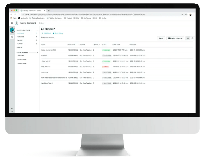
About Planet's Tasking Dashboard
With Flexible Tasking, you can access the data you need, when you need it. The easy-to-use Tasking interface is accessible from anywhere, and allows you to autonomously submit, modify, and cancel satellite imagery requests online. The process is automated, and provides you with near real-time updates from order to fulfillment. When the order is completed, the assets are delivered directly to you through Planet’s powerful, cloud-based infrastructure.
Please note the minimum order of €4,500.00.
About SkySat imagery
Find in the table below some more details about the SkySat product specifications that are essential for your order.
Processing level | Basic Scene (L1) | Ortho Scene (L3) |
Analytic | Unorthorectified, radiometrically corrected, multispectral BGRN* | Orthorectified, multispectral BGRN*. Radiometric corrections applied to correct for any sensor artifacts and transformation to top-of-atmosphere radiance |
Analytic DN | Unorthorectified, multispectral BGRN* | Orthorectified, multispectral BGRN*, uncalibrated digital number imagery product. Radiometric corrections applied to correct for any sensor artifacts |
| Panchromatic | Unorthorectified and radiometrically corrected panchromatic (PAN) | Orthorectified and radiometrically corrected panchromatic (PAN) |
| Panchromatic DN | Unorthorectified panchromatic (PAN) | Orthorectified, panchromatic (PAN), uncalibrated digital number imagery product |
| L1A Panchromatic DN | <10 m Unorthorectified, pre-super resolution, panchromatic (PAN) | - |
| Visual | - | Orthorectified, pansharpened, and color-corrected (using a color curve) 3-band RGB Imagery |
| Pansharpened Multispectral | - | Orthorectified, pansharpened 4-band BGRN* Imagery |
*BRGN: Blue-Green-Red-Near Infrared (4 bands)
Standard allowable cloud cover is 15%. Maximum cloud coverage is also available at 5% and 10% as an extra cost. Collection area, time period, and other specifications subject to feasibility. For stereo pairs or tri-stereo imagery, please specify in the Remarks box.
And some general info for the SkySat constellation:
Launch | SkySat-1: November 21, 2013SkySat-2: July 8, 2014SkySat-3: June 22, 2016SkySat-4,5,6,7: September 16, 2016SkySat-8,9,10,11,12,13: October 31, 2017SkySat-14,15: December 3, 2018SkySat-16,17,18: June 13, 2020SkySat-19,20,21: August 18, 2020 |
Orbit | Skysat 1-15: Sun-synchronous Skysat 16-21: inclined, non sun-synchronous |
Spectral bands | Pan: 450 - 900 nm Blue: 450 - 515 nm Green: 515 - 595 nm Red: 605 - 695 nm NIR: 740 - 900 nm |
| Spatial resolution | 0.5m (resampled) |
| Radiometric resolution | - Visual: 8 bit - Analytic, panchromatic, and pansharpened multispectral: 16 bit |
| Geometric precision | <10 m RMSE |
| Revisit time | Daily |
Key features
Enhanced 50 cm spatial resolution images
API to synchronize within existing workflows
300 million+ square kilometers of imagery collected daily
Actionable insights between 5-7 times per day
Cloud-based dashboard makes Tasking simple and possible anywhere
Delivery in less than three hours from capture
Key applications

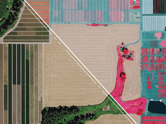
Agriculture
Assessment of crop damage and crop progress
Drought Monitoring
Continuous crop yield modelling and estimation
Assessment of crop damage and crop progress
Drought Monitoring
Continuous crop yield modelling and estimation
Forestry
Prevention of illegal and unpermitted forest clearing
Timber harvest optimization
Monitoring and management of forest health
Prevention of illegal and unpermitted forest clearing
Timber harvest optimization
Monitoring and management of forest health
Prevention of illegal and unpermitted forest clearing
Timber harvest optimization
Monitoring and management of forest health

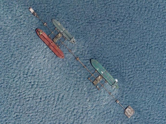
Marine
Oil spill mapping and position forecasting
Coastline monitoring
Shallow waters bathymetry
Oil spill mapping and position forecasting
Coastline monitoring
Shallow waters bathymetry
FAQs
The SkySat L1 Basic Scene product is a Scaled Top of Atmosphere Radiance (at sensor) and sensor corrected product, without correction for any geometric distortions inherent in the imaging processes and is not mapped to a cartographic projection. The imagery data is accompanied by Rational Polynomial Coefficients (RPCs) to enable orthorectification by the user. This kind of product is designed for users with advanced image processing and geometric correction capabilities.
The SkySat L3 Ortho Scene product is radiometrically-, sensor- and geometrically- corrected and is projected to a cartographic map projection. The geometric correction uses fine Digital Elevation Models (DEMs) with a post spacing of between 30 and 90 meters.
SkySat imagery is published within less than 10 hours of collection, or less than 3 hours with express delivery on request.
Pricing depends on a variety of factors, including area of interest, time of interest, and the number of collects needed.
Minimum area of interest is 25km², with at least 2km in one direction.
The minimum order for SkySat Flexible Tasking is €4,500.
In case more than one AOI is required, please contact us for a custom order tailored to your needs.
The EULA of SkySat Flexible Tasking is under the authority of Planet Labs and can be found here.