Introduction to UAV mapping
Introduction to UAV mapping is a simple but in-depth course for new professionals and amateur drone pilots that want to enter the world of aerial mapping and surveying.
The course will provide you with all the basic knowledge you will need, so that after completion you will be able to plan your own projects and produce excellent maps, DEMs and 3d models, as well as demonstrate some serious skills that are a must in the UAV industry.
Instructor: Panagiotis Gryllis, GIS Expert and Certified Professional UAV Pilot.
The course is also included in GEO Premium.
What you'll learn
How to select the right UAV for performing professional mapping projects within your budget and needs.
UAV flight software specifications and functionality.
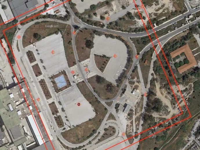
Planning, deploying and measuring ground control points (GCPs)
Air mapping mission and image specifications.
Air mapping theory: Altitude, image overlap, GSD, relative and absolute accuracy.
Professional mapping flight performance from the start to the end.
Key features
A simple but in-depth course for new professionals and amateur drone pilots.
Claim your Certificate of Completion with no extra cost.
Study at your best time - online and always accessible.
Even when you finish the course and you get your certificate, you will still have access to course contents.
Key applications

Train your company
Train newest members
Stay updated on GIS applications, Remote Sensing techniques and Space technologies

Research & Academia
Fill in knowledge gaps
Continuing education on GIS applications, Remote Sensing algorithms and techniques and Space technologies
Fill in knowledge gaps
Continuing education on GIS applications, Remote Sensing algorithms and techniques and Space technologies
FAQs
The online course is hosted in the platform of GEO University. After the purchase, you will be sent further information on how to access the course from the GEO University platform.
You get access to the course for ever! You pay once and you get access to the entire course content and their updates for ever.
No. Your certificates of completion remain active for ever.
You can share it in your social media accounts and you can add it to your CV, LinkedIn profile etc as proof of knowledge.
In case you want multiple people to access the course, please fill out the Quotation Form below and add your exact needs in the 'Your Question' field. We will contact you as soon as possible!
Terms & Conditions and Privacy Policy of GEO University apply.